Fast-moving Hurricane Helene was advancing Thursday across the Gulf of Mexico toward Florida, threatening an “unsurvivable” storm surge in northwestern parts of the state as well as damaging winds, rains and flash floods hundreds of miles inland across much of the southeastern U.S., forecasters said.

Helene was upgraded Thursday morning to a Category 2 storm and is expected to be a major hurricane — meaning a Category 3 or higher — when it makes landfall on Florida’s northwestern coast Thursday evening. As of early Thursday, hurricane warnings and flash flood warnings extended far beyond the coast up into south-central Georgia. The governors of Florida, Georgia, the Carolinas and Virginia have all declared emergencies in their states.
Rain was beginning to blow in the predawn darkness Thursday along coastal U.S. Highway 98, which winds through countless fishing villages and vacation hideaways along Florida’s Big Bend. Shuttered gas stations dotted the two-lane highway, their windows boarded up with plywood to protect from the storm. The road was largely empty at first light on Thursday, with what drivers there were mostly heading northeast, towards higher ground.
The storm was expected to make landfall in the Big Bend region, where Florida’s panhandle and peninsula meet, according to Jack Beven, senior hurricane specialist at the National Hurricane Center in Miami.
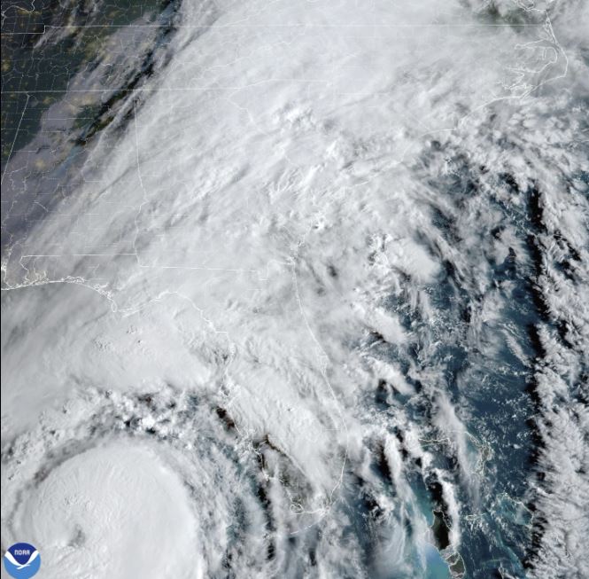
This satellite image provided by NOAA shows Hurricane Helene advancing across the Gulf of Mexico toward Florida on Thursday, Sept. 26, 2024.
NOAA
“Regardless of how strong it is, it is a very large storm, Beven said. “It’s going to have impacts that cover a large area.”
The National Weather Service office in Tallahassee forecast storm surges of up to 6 metres and warned they could be particularly “catastrophic and unsurvivable” in Florida’s Apalachee Bay. It added that high winds and heavy rains also posed risks.
“This forecast, if realized, is a nightmare surge scenario for Apalachee Bay,” the office said. “Please, please, please take any evacuation orders seriously!”
This stretch of Florida known as the Forgotten Coast has been largely spared by the widespread condo development and commercialization that dominates so many of Florida’s beach communities. The sparsely populated region is loved for its natural wonders — the vast stretches of salt marshes, tidal pools and barrier islands; the dwarf cypress trees of Tate’s Hell State Forest; and Wakulla Springs, considered one of the world’s largest and deepest freshwater springs.

In Crawfordville, farther inland and about 40 kilometres northwest of Apalachee Bay, Christine Nazworth stocked up on bottled water, baked goods and premade meals at a Walmart. She said her family would be sheltering in place, despite Wakulla County issuing a mandatory evacuation order.

Get breaking National news
For news impacting Canada and around the world, sign up for breaking news alerts delivered directly to you when they happen.
“I’m prayed up,” she said. “Lord have mercy on us. And everybody else that might be in its path.”
Along Florida’s Gulf Coast, school districts and multiple universities have cancelled classes.
Helene was about 515 kilometres southwest of Tampa on Thursday morning and moving north-northeast at 19 km/h with top sustained winds 155 km/h. Forecasters said it should become a Category 3 or higher hurricane, meaning winds would top 177 km/h.
While Helene will likely weaken as it moves inland, its “fast forward speed will allow strong, damaging winds, especially in gusts, to penetrate well inland across the southeastern United States,” including in the southern Appalachian Mountains, the hurricane center said. The center posted lesser tropical storm warnings as far north as North Carolina, and warned that much of the region could experience prolonged power outages, toppled trees and dangerous flooding.
Waves from the Gulf of Mexico push up against the shore as Hurricane Helene churns offshore on September 26, 2024 in St. Pete Beach, Florida. Later today, Helene is forecast to become a major hurricane, bringing the potential for deadly storm surges, flooding rain, and destructive hurricane-force winds along parts of the Florida West Coast.
Joe Raedle/Getty Images
Helene had swamped parts of Mexico’s Yucatan Peninsula on Wednesday, flooding streets and toppling trees as it passed offshore and brushed the resort city of Cancun.
The storm formed Tuesday in the Caribbean Sea. In Cuba, the government preventively shut off power in some communities as waves as high as 16 feet (5 meters) slammed Cortes Bay. And in the Cayman Islands, schools closed and residents pumped water from flooded homes.
Helene is forecast to be one of the largest storms in breadth in years to hit the region, said Colorado State University hurricane researcher Phil Klotzbach. He said since 1988, only three Gulf hurricanes were bigger than Helene’s predicted size: 2017’s Irma, 2005’s Wilma and 1995’s Opal.
Areas 160 kilometres north of the Georgia-Florida line can expect hurricane conditions. More than half of Georgia’s public school districts and several universities canceled classes.
For Atlanta, Helene could be the worst strike on a major Southern inland city in 35 years, said University of Georgia meteorology professor Marshall Shepherd.
Landslides were possible in southern Appalachia, and rainfall was expected as far away as Tennessee, Kentucky and Indiana.
People look out at the waves from the Gulf of Mexico pushing up against the shore as Hurricane Helene churns offshore on September 26, 2024 in St. Pete Beach, Florida. Later today, Helene is forecast to become a major hurricane, bringing the potential for deadly storm surges, flooding rain, and destructive hurricane-force winds along parts of the Florida West Coast.
Joe Raedle/Getty Images
Federal authorities have positioned generators, food and water, along with search-and-rescue and power restoration teams.
Helene is the eighth named storm of the Atlantic hurricane season, which began June 1. The National Oceanic and Atmospheric Administration has predicted an above-average Atlantic hurricane season this year because of record-warm ocean temperatures.

In further storm activity, Tropical Storm Isaac formed Wednesday in the Atlantic and was expected to strengthen as it moves eastward across the open ocean, possibly becoming a hurricane by the end of the week, forecasters said. Isaac was about 1,115 kilometres northeast of Bermuda with top sustained winds of 85 km/h, according to the hurricane center, which said its swells and winds could affect parts of Bermuda and eventually the Azores by the weekend.
In the Pacific, former Hurricane John reformed Wednesday as a tropical storm and strengthened Thursday morning back into a hurricane as it threatened areas of Mexico’s western coast with flash flooding and mudslides. Officials posted hurricane warnings for southwestern Mexico.
John hit the country’s southern Pacific coast late Monday, killing at least two people, triggering mudslides, and damaging homes and trees. It grew into a Category 3 hurricane in a matter of hours and made landfall east of Acapulco. It reemerged over the ocean after weakening inland.
© 2024 The Canadian Press